

DAY 1. DIRECTION PLYMOUTH
Leicester, England –> Plymouth, England (250 miles)
We’re back on the road. After a couple smaller trips it was time for a bigger one, this time to the warm regions. Our target was to reach the farthest west and south of Europe. On that day, right after work we quickly get on the bike and set off in the direction of Plymouth, as there was long way to go. Forecast was unfavourable for that day and it proved right. Fortunately, only the last several dozen miles we drove in rain. There were some traffic jams and obstacles on the motorways, but we managed to arrive on time. We boarded the ferry, ate small dinner and quickly went to sleep.
DAY 2. FROM ROSCOFF TOWARDS THE SUN
Roscoff, France –> Rochefort, France (365 miles)
We’ve been woken up by music from the radio on the ferry at 6 in the morning. While we were eating a light breakfast, the ferry entered the port. The sky was overcast, but we were not worried as it was still early in the morning and we hoped it will clear up later.
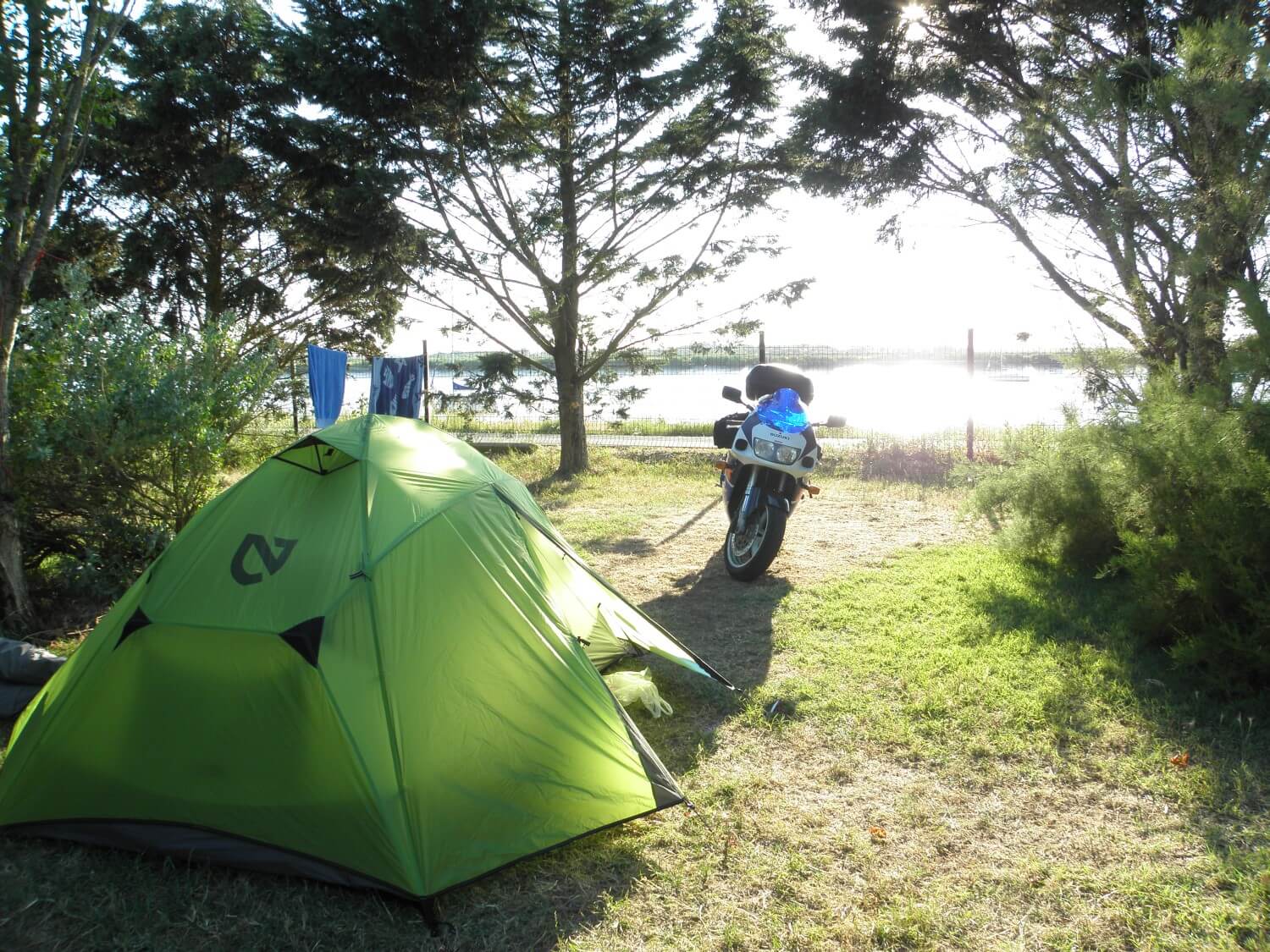 To start with we got lost in Roscoff trying to find the right way out of the city. Once we found it, we drove quickly towards the sun. The weather was getting better with every hour, until finally the sky cleared up and we could bask in the sun. Today we planned to familiarize ourselves with surroundings, we’ve travelled a long distance as the drive went very well. We stopped at campsite and stretched our legs, we felt the first signs of fatigue and aching bum.
FRANCE – southern part is a typical lowland area, with highly mechanized agriculture
DAY 3. THROUGH THE PYRENEES
Rochefort, France –> Eratzu, Spain (275 miles)
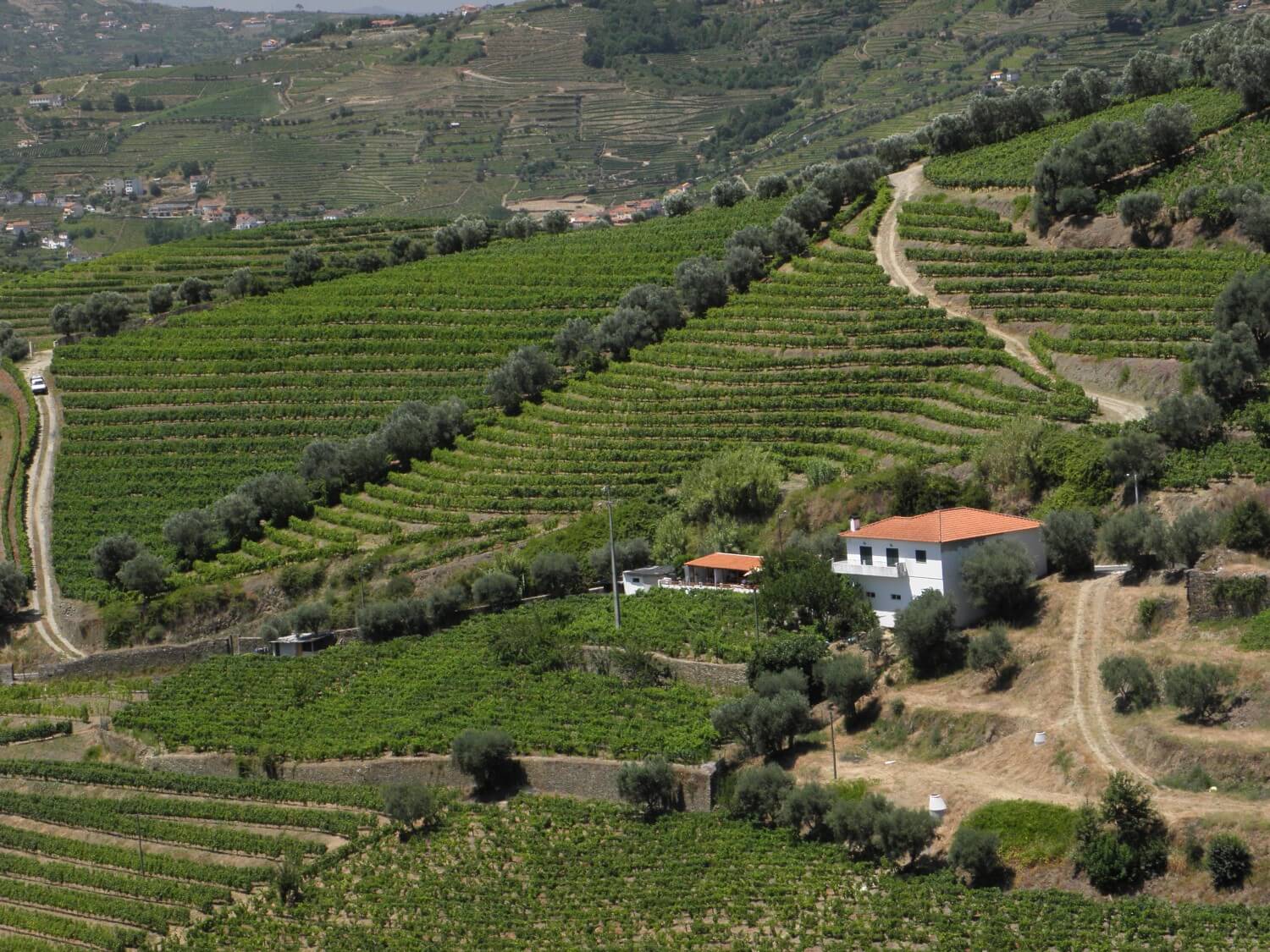
There is surely something special in mountains… but let’s start from the beginning. We woke up quite late after a tough and sleepless night. In the morning our first attraction was – a ferry crossing in the company of a variety of motorcycles. Later we got lost several times, miles were passing but we haven’t moved far forward, but at least we saw beautiful vineyards stretching for miles on the west coast of France.
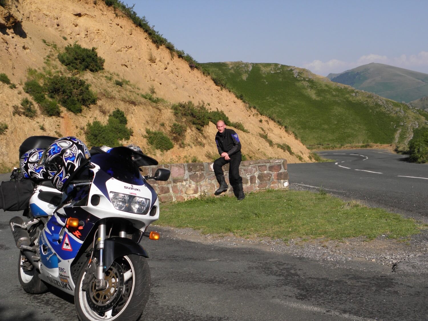 After a lot of searching we got out of the loop and headed towards the mountains. The heat was unbearable from the very morning. With every hour the drive was getting more exhausting, but luckily when we reached the mountains it got a little colder, because we were traveling in the shade of trees and mountains. We passed the first hairpin bends, driving through the charming valley. Shortly after crossing the border with Spain we stopped on the first campsite on our way.
DAY 4. PICOS DE EUROPA
Eratzu, Spain –> Riaño, Spain (299 miles)
 How good is to wake up in a dry tent:) Another day in Spain, for us it was a completely new landscape. It started quite nicely, the drive went well, and we passed few hairpin bends in the morning. We stopped in Reinosa for a lunch. In the restaurant no one spoke English, so we really didn’t know what we’ve chosen, but it was very tasty. It was a nice change after a couple of days of eating on the way.
Today was a little colder, as most of the time we were driving in the mountains. We could not get enough of the spectacular views on the N621 route, which led through picturesque gorges of Picos De Europa 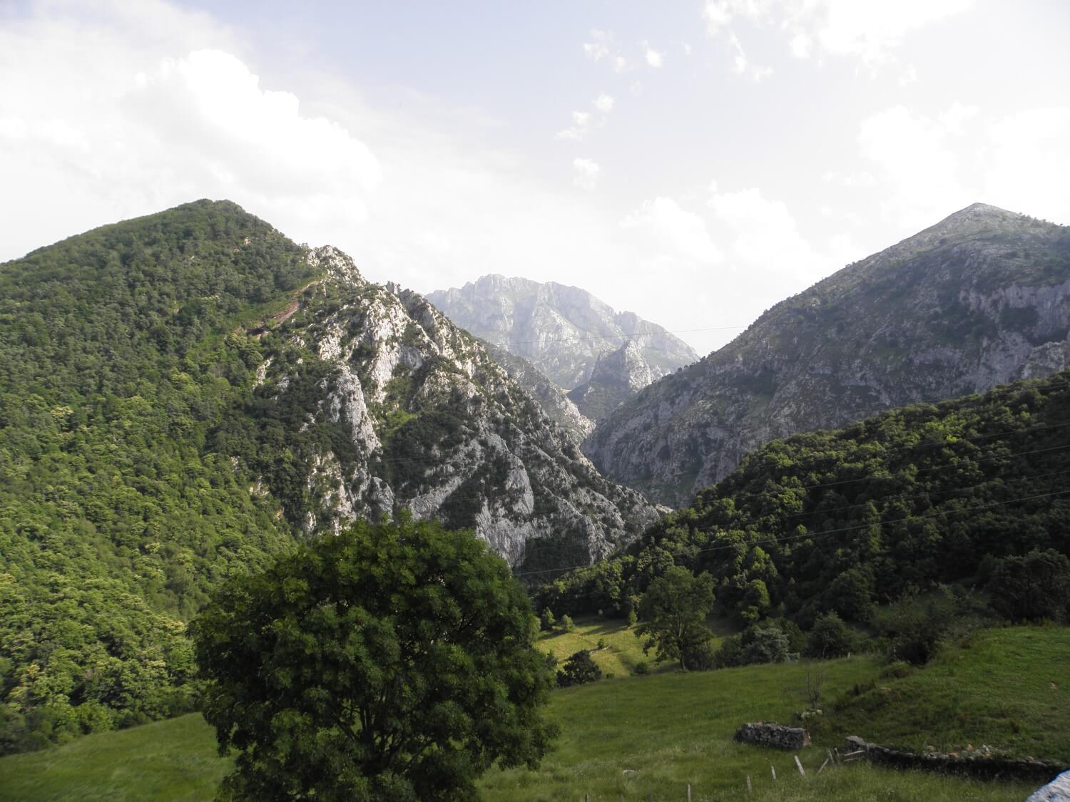 (northern Spain). As usual we tried to avoid big cities, choosing roads through villages and small towns. And Spanish villages are very charming, built of red stones, with wooden shutters in windows, and balconies full of flowers. It seems that life goes very peacefully here, and you can hardly meet anyone. Only as the siesta time passes you could see people working in the fields.
SPAIN surprised us with good quality road (and views as well), driving was really enjoyable:)
DAY 5. DAY OF MISTAKES
Riaño, Spain –> Allariz, Spain (304 miles)
Today morning’s unpleasant surprise was wet tent. Later there were more unpleasant surprises. We could not avoid turning back, losing the way and detouring. It was all due to road markings, which sometimes were missing and thus we were getting lost. We got lost in Ourense in Spain which worsened our mood. For this reason, we pulled off onto campsite only about 20.30, exhausted, and I also got cold.
Today we travelled mainly in the mountains and the clouds. You could feel that on the temperature, I was driving in a fleece. Mountain landscapes delighted as always, but today I was enjoying more the drive itself, it went so well – the roads wide and smooth, bend after bend… a pleasure to drive. Later on the road led through a much industrialised area, lots of mines, power plants, aggregate plants and the like.
At the end of the day an unpleasant surprise – the motorcycle lamp has broken down (déjà vu from Scandinavia:/)
DAY 6. PROBLEMS WITH TENT
Allariz, Spain –> Coja, Portugal (229 miles)
 We woke up to the cold, because of it I did not get much sleep. It was so cold that for the first time we took our kettle out and we made some hot tea to warm up.
In the morning we crossed the border and entered Portugal. Our route was amazingly scenic. The N2 road led us on the slopes of hills planted with vines. The whole hillsides covered with vineyards planted on beautiful terraces, and in between them were hidden small villages of white houses with red roofs. And above this all the blue sky stretched… just wonderful.
We got lost few times in the cities, but unfortunately there are so many of them here, that it is impossible to bypass them. Today we took a longer break during the day for a proper dinner – pizza in Lemago… and finally we could communicate in English.
Today’s day of setting up the tent will make history. We intentionally pulled off onto the camp site earlier than usual in order to relax, de-stress. However, setting up the tent, which usually takes us 15 min, this time took us 2 hours, as it later proved that every time we put the tent frame the wrong way round. Instead of two hours of relaxation we had two hours of a stressful “fight” with a tent, which eventually ended in OUR victory.
DAY 7. CABO DA ROCA
Coja, Portugal –> Camping Guincho, Portugal (251 miles)
Another day in Portugal. Today’s plan was to get to Cabo da Roca, which took us almost whole day. At the beginning we wandered around the small roads and lanes. The N236-1, N237 roads are worth travelling, winding, leading through forests and offering spectacular views. On the way we ate a late breakfast, because of course we had a problem with finding a picnic table.
 Later we got onto the motorway in order to get to the coast quickly and make up some miles.
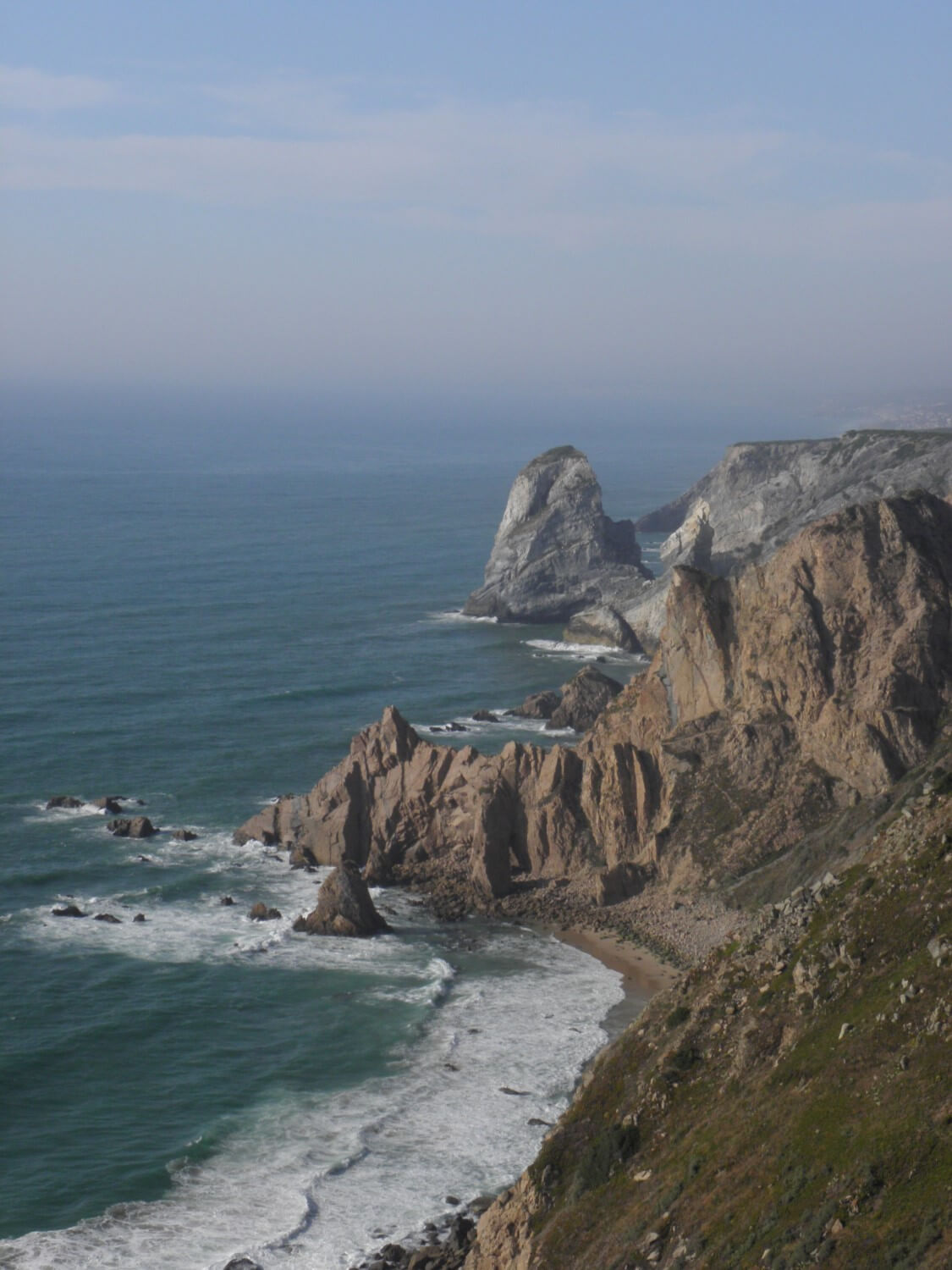
To Cabo da Roca we got following the N247 road, very scenic route. The traffic there was much heavier that in Spain, so it was 18.00 pm already when we reached our destination. We took a “must-have” photo and admired the nearby rock formations and cliffs. The sea breeze alleviated the heat, thus it wasn’t so hot. We drove onto the nearest campsite, which turned out to be quite big holiday resort. We had dinner at the local restaurant and went for a walk late in the evening.
DAY 8. DAY OF TROUBLES
Camping Guincho, Portugal –> Camping Valverde, near Luz, Portugal (267 miles)
The first problem was to get through Lisbon. We got up early in the morning, we left shortly after 7 o’clock to avoid the traffic in the city. Of course we took the wrong exit and we had to turn back. The traffic was getting heavier, but somehow we managed to get through. Later it got worse. We wanted to take the N-249-1 road leading along the coast. We wandered around more than an hour and we could not find it. We had to give up and took an alternative route.
Another town and more problems, we couldn’t find the way out of Setubal. That was yet another reason, which convinced us that big cities should be avoided. In the end we managed to get through, but then another surprise was awaiting us. We stopped for a longer break to get some food, and during that time the motorcycle battery has gone flat, because we left the lights on. After our attempts to communicate with the men from the petrol station it turned out that unfortunately he didn’t have the jump leads. Fortunately… we managed to push start the bike:)
We followed the IC1 road, which lead through the “Portuguese steppes” (as we called it). The vast area covered with dry grass and widely spaced, low trees. The air was incredibly hot, did not give any refresh. At some point it began to blow awfully and a moment later the thunders and rain came.
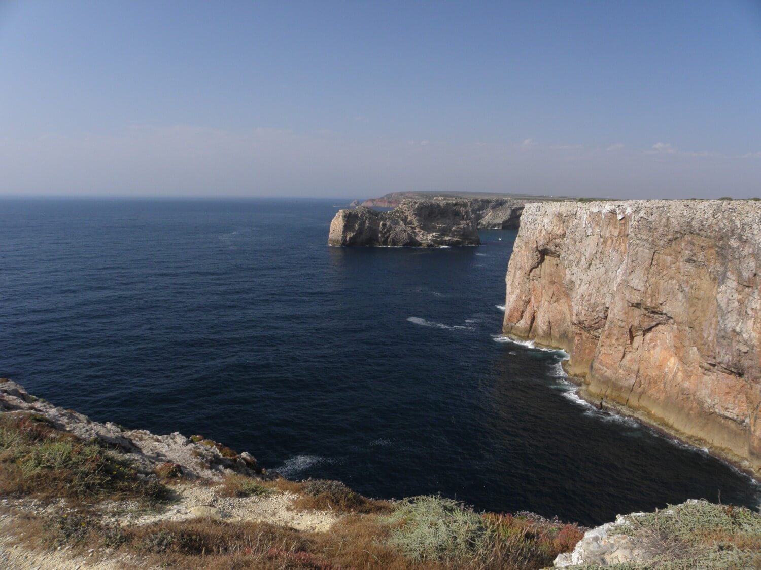 We waited at the bus stop for the storm to stop. Unfortunately, the air did not cool at all. Today’s attraction was Cabo de Saint Vincento – a cape which charmed us more than Cabo da Roca. High cliffs surrounded by dark blue ocean waters. In this scenery we allowed ourselves for a moment of relaxation in the rays of the setting sun.
DAY 9. TARIFA
Camping Valverde, near Luz, Portugal –> Jimena de la Frontera, Spain (347 miles)
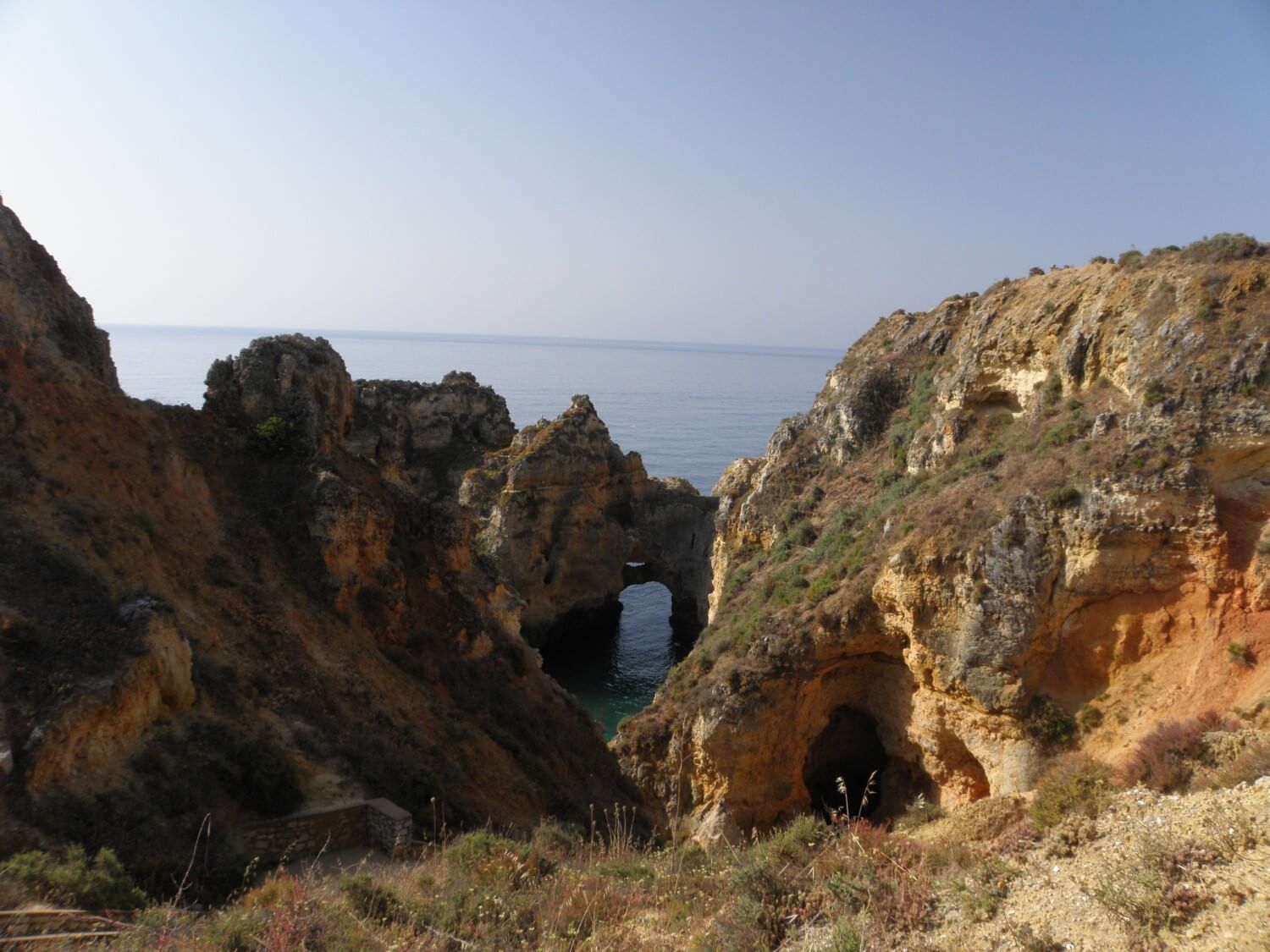 In the morning we arrived at Lagos looking for a view point at the cliff formations. The views were spectacular – the orange-brown cliffs contrasted beautifully with the turquoise ocean and blue cloudless sky. We could marvel at that miracle of nature in peace, because it was still early in the morning and only few people around. We ate some breakfast there and also we decided that we will get to Tarifa via motorway.
We left Portugal travelling on motorways making short stops to quench our thirst and to relieve our aching bums.
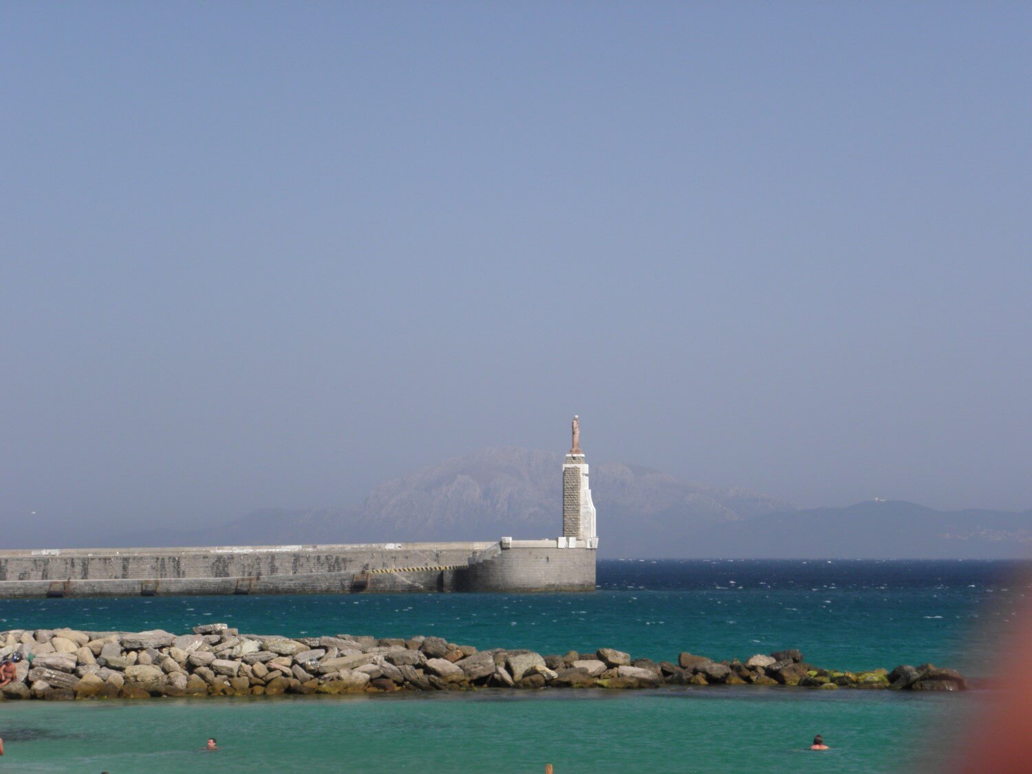 We aimed to stop for longer in Tarifa, which is the southernmost point of Spain and Europe. Travelling the route along the coast was very pleasant, we could admire the nearby beaches and the ocean, although it was getting a little crowded. Tarifa itself was full of tourists, and the roads were marked poorly. We drove down to one of the beaches, but we soon left it, as we don’t like so crowded places.
We moved on looking for a campsite, feeling more and more the hardships of the journey. With every minute the fatigue grew worse and the drive wasn’t so nice any more. Finally we managed, by mere chance, to spot a sign in a small village pointing to a campsite – we were saved:) That day we did many miles. Thanks to the shower and a decent dinner we have recovered. In the evening we were relaxing drinking Sangria.
PORTUGAL – poorly marked roads, and because of it we got lost many times and to say the truth with some relief we left this country and entered Spain again.
DAY 10. SIERRA NEVADA
Jimena de la Frontera, Spain –> Orgiva, Spain (293 miles)
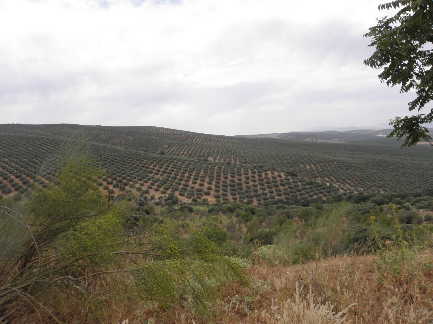 In the morning we woke up rested, we packed our staff, got on bike and set off. We left quite late, but we’ve drove long distance, as we didn’t get lost. Today we spend a lot of time in the mountains, which we could feel on the temperature – it was cooler and the drive was much more pleasant. The road led mainly through olive plantations. The hills covered with olive trees stretched for miles – fantastic views.
Today’s attraction was the drive through the Sierra Nevada range. We got to a height of 2500 m above sea level.
 The wide road led to the top, where it was quite cold and terribly windy. Unfortunately we had to go back to Granada, as there is no road through the massif. We turned into the A384 road, which is very picturesque. We stopped on the first campsite on our way and this time instead of setting the tent first as usual, we went to get something to eat. As a result we had to set up the tent in the dark and we gave up a shower, as it turned out that there was no hot water either.
INTERESTING FACT – we passed many oranges plantations, and for us it was unthinkable how many of those oranges are wasted, many lying on the ground and nobody seems to care, and to think that every day one can’t justify whether to buy oranges because they are expensive…
INTERESTING FACT – Spain is a land of thousands scents, everything all around and especially herbs give off intense aromas, which are best to marvel in the evening.
DAY 11. SORE BOTTOM
Orgiva, Spain –> Camping Rural Montillana near Tranco, Spain (223 miles)
Todays drive wasn’t that pleasant, even though the road was excellent. From early morning it was very warm and with every hour it was getting even hotter, and such conditions are not good for motorcycling, especially with the sore bottom.
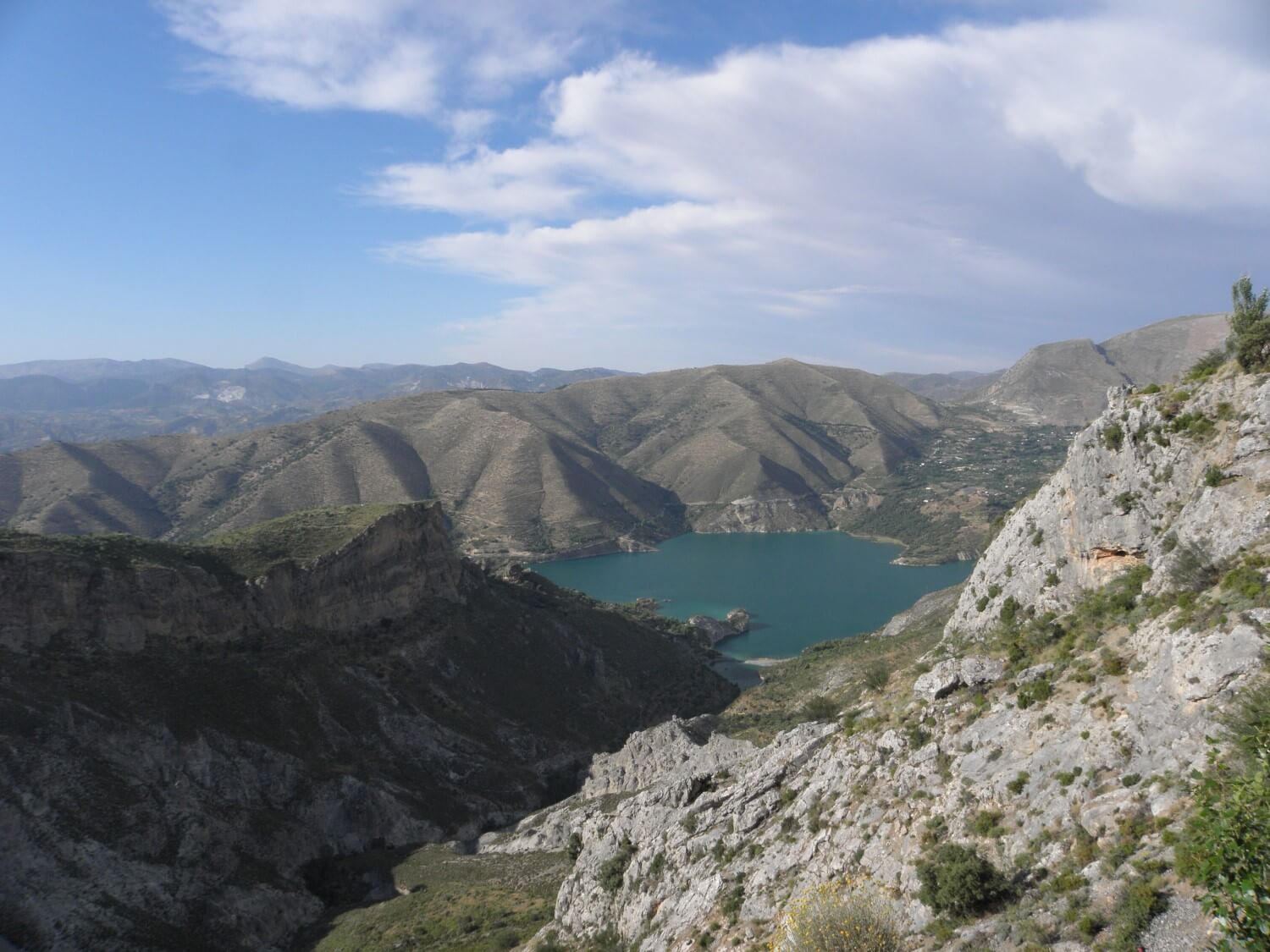
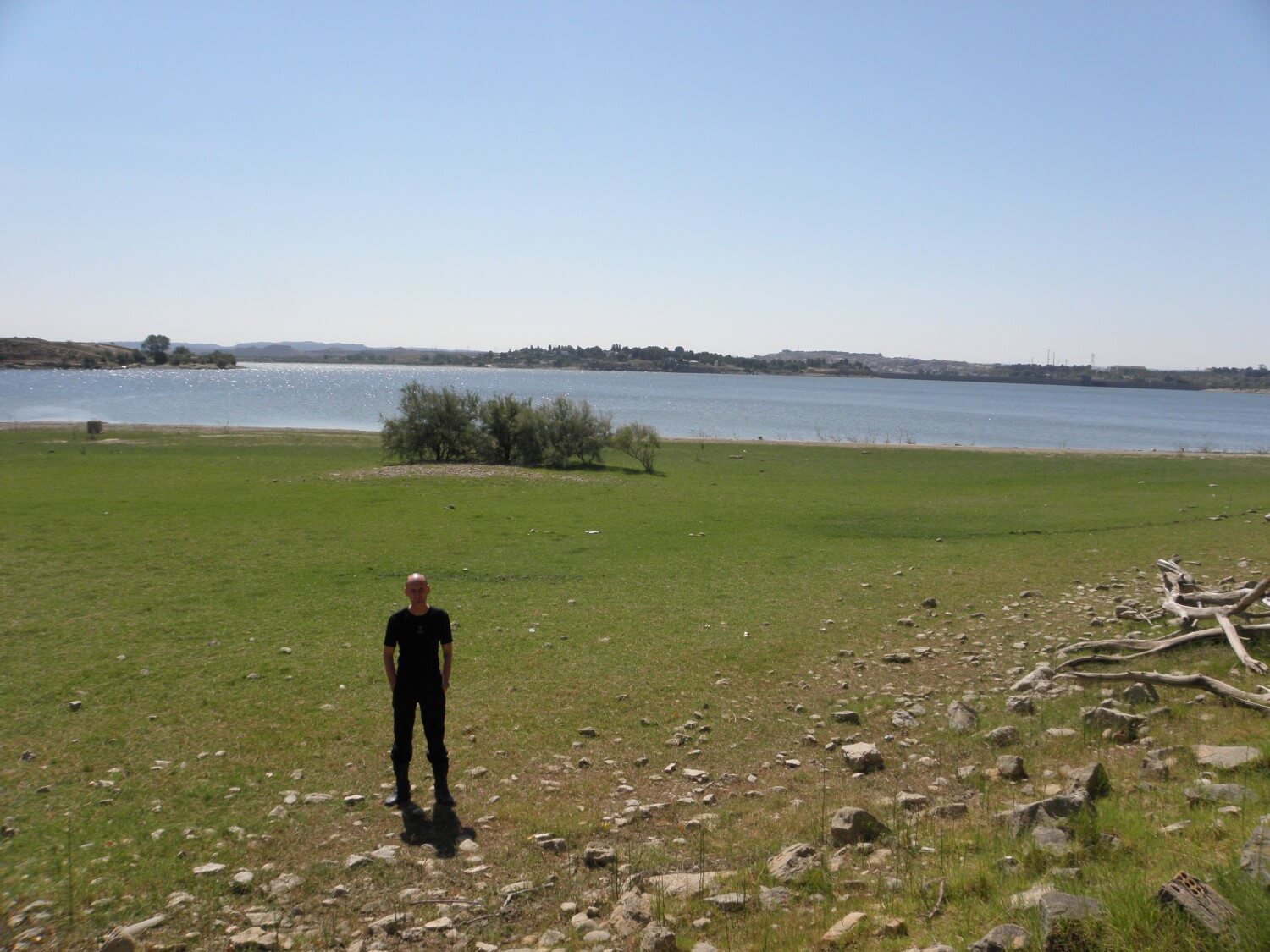
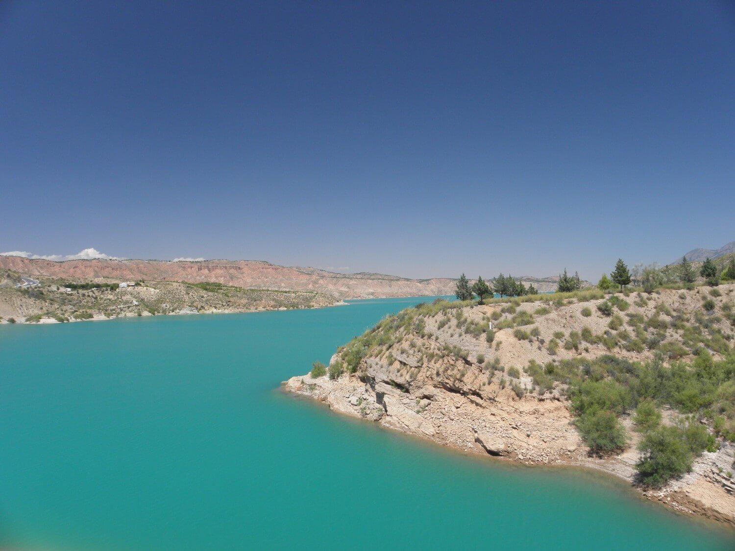 The roads we drove today were very good. First we went through the Sierra Nevada range, circling it from the south. We ate breakfast at the height of 2000 m above sea level. We even managed to find a picnic table in the woods – and everything tasted much better:) Then we passed through the Sierra de Seguera range, which surprised us at the beginning with the lake of incredible turquoise water, surrounded by orange hills – an out-of-this-word view. Next we followed the A315 road from Cazorla to Hornas, which led through the hills, forests and then circling the picturesque lake of sky blue water. In one of the forests we have found a campsite with a restaurant (which is very common in Spain). In the restaurant we regaled our palates with local delicacies while relaxing and drinking Sangria.
DAY 12. CAMPING FOR THE EXCLUSIVE USE
Camping Rural Montillana near Tranco, Spain –> Castellote, Spain (369 miles)
It was a very looong day. We got up quite early, assuming that it will be a typical day of driving, but it turned out that we came across a few nice stretches of road.
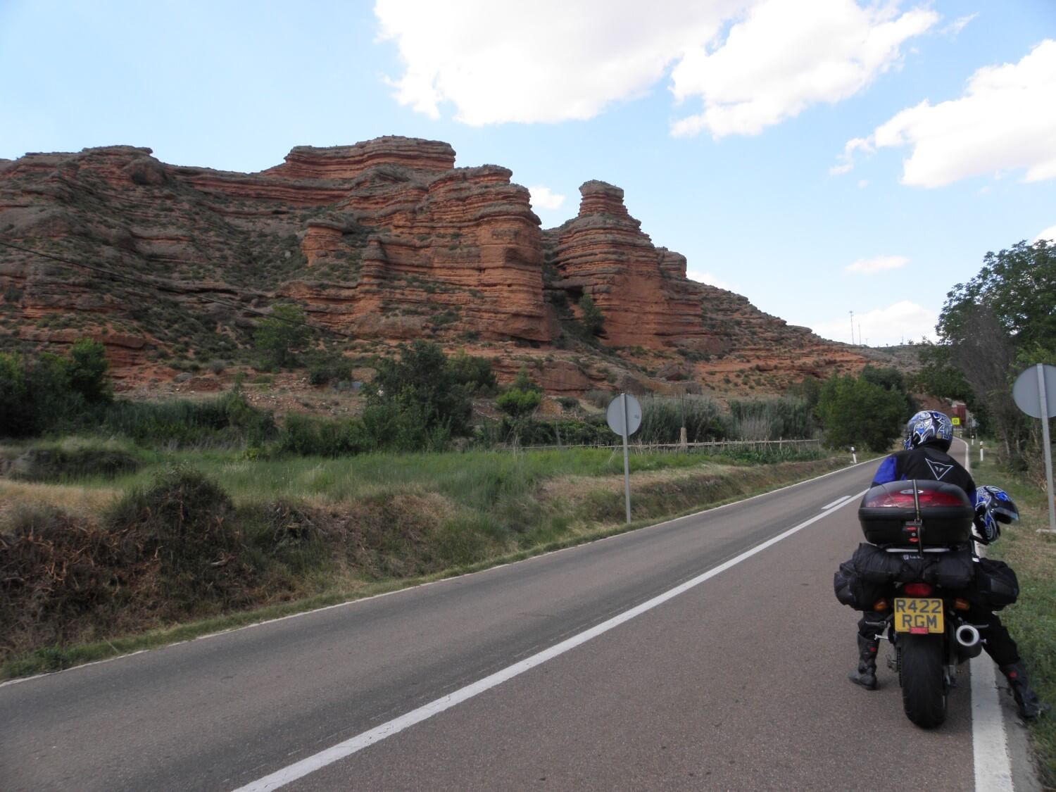 For example the N330 road towards Teruel led a spectacular route along the river. Another road – A226 towards Castellote is surrounded by rugged massifs and rock formations presenting itself beautifully in the light of the setting sun.
At the end of the day we got into the mountains and we had some problems finding the campsite. We were driving the side roads, through small, charming town and villages embedded into the mountain slopes, where time seemed to have stopped.
After a long search we arrived at Castellote. The campsite turned out to be completely empty, so we thought it was abandoned, but fortunately it was not. Although we paid €27, but we had this campsite just for ourselves:)
DAY 13. BACK IN THE PYRENEES
Castellote, Spain –> Arties, Spain (293 miles)
That day we’ve done many miles. In the morning the road led through the agricultural areas, it was warm and dry. We ate breakfast on the bank of the Rio Ebro.
 Then we headed towards the mountains until we got in the Pyrenees and here we were surprised with the change of landscapes and colours. After the morning yellow colours (red, dry, scorched land) now we were surrounded with all shades of green. We were surprised that the Pyrenees are so intensely green and covered with woods. The road meandered along streams, through ravines, defiles, tunnels until the eyes enlivened with the change of colour and landscape.
At the end of the day we had a little surprise. We drove in the sun all day long and it was very warm, at some point we entered the tunnel, fairly long, as about 3 miles. When we left it we found ourselves like in another world – the sky was overcast, we could not see the mountains, it was dark, cloudy and terribly cold, at least 10 degrees less than before entering the tunnel. My first thought was: let’s go back:) According to the earlier decisions though, we stopped at the first campsite after leaving the tunnel. Due to the much lower temperature we were forced to wear long trousers and fleeces.
DAY 14. ACROSS ANDORRA
Arties, Spain –> Mazamet, France (259 miles)
I am not sure why, but it was so painstaking day. We said goodbye to Spain driving above the clouds for some time, passing hairpin bends one after another. We entered Andorra where however we did not stay for long. Driving the mountain roads, winding up the slopes was very pleasant, and in no time we were at the border.
 Leaving Andorra we entered France. At the beginning we came to conclusion that the French roads are not the best quality, especially the local ones. For this reason todays drive was so painstaking, because driving on a bumpy road isn’t pleasant at all and the journey drag on terribly.
Going down the mountain we drove into the valley and it got cloudy and cold and so it remained until the end of the day. Unfortunately we had to drive through Carcascone, quite big city and there we had some problems. We came across road works, some of the roads were closed, diversions not marked properly, so we pulled off resigned into a side street and stood there helplessly. And then suddenly a car stopped by: “Have you got lost?” “Yes, we want to get to Mazamet”. After a moment, the man in the car kindly said: “So just follow me”, and then skilfully led us through the streets, parking lots and got us on the road out of the city. It was very positive accent of this trip. Again we had problems with finding the campsite. Yes, there were few along the way, but they were so called “a la ferme”. These are places, where you can set up a tent, you have access to the drinking water, but they are most often located far from the cities. And as we were hungry we decided to get to Mazamet and stop for the night there, at the city campground.
DAY 15. THE MILLAU VIADUCT
Mazamet, France –> Saint Julien En Saint Alban, France (264 miles)
I woke up earlier than Marcin, I made some notes in our travel diary, marked the routes on the map and prepared the route for today. We packed up very quick and set off. On the way we stopped for some breakfast with delicious French baguette and a strawberry cake…
The road we were following was very pleasant, it led along the river, surrounded by high rocks – 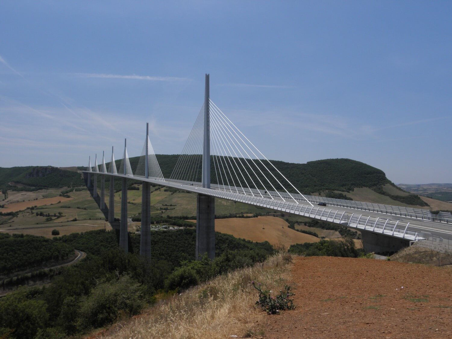 it was a canoeing and rafting centre. With every hour it was getting warmer, but the drive was nice. We arrived at Millau, where we got on the famous viaduct, which later we admired from the view point. It’s amazing what people can create. Viaduct presented itself nicely against the blue sky. We drove on through the mountains and hills towards the south coast of France. We had a break for and apple, to stretch our legs and for a French pizza (although it wasn’t the right thing to call it pizza).
NOTE – The traffic in France is much heavier, in addition on the way there are many small towns and speed limits, and all that slows you down and often makes you weary.
DAY 16. MONACO
Saint Julien En Saint Alban, France –> Sospel, France (264 miles)
The previous evening we decided not to put the fly over the tent. This proved to be a big mistake, as the morning dew condensed on the tent and we woke up in damp sleeping bags. Luckily there was a bit of sunshine in the morning, so we managed to dry the sleeping bags.
We started the day quite well, later it wasn’t that good, as we got stuck in the traffic jams. Even though we were not travelling through cities, the traffic was quite heavy and the roads were congested. Later on it got better, the road led through the mountains and hills, hairpin bends and gorges. I didn’t even expect that the southern France is so mountainous.
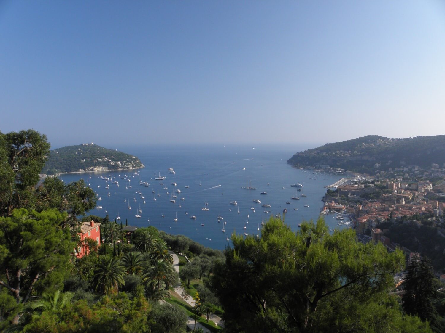 Today’s attraction was Monaco. To get there we reached the road which ran along the coast and first we drove through Nice. I was expecting highways, roads through the crowded cities, and there was such a nice surprise – the road winded up the coastal slope, with the sea at the bottom, and we were going higher and higher passing many hairpin bends and enjoying the wonderful views. On entering the Monaco, we got the feeling as if we entered a different world – wealth, splendour and richness all around. Blue colour of the sea contrasted with white luxury yachts, the coastal slope overflowing with exotic plants, among which were located villas with pools – an extraordinary view.
DAY 17. THROUGH THE MOUNTAIN PASSES
Sospel, France –> Lanslebourg Mont Cenis, France (221 miles)
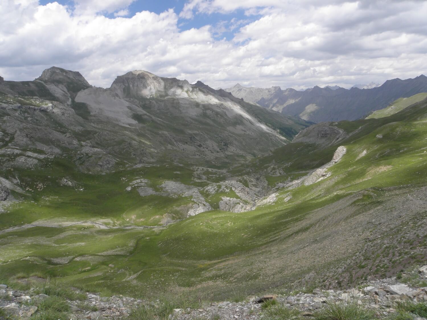 Oh my, we were really high today. We started the day from climbing up and we finished it the same. At the beginning leisurely, some 800, 1500 meters and then even more than two thousand. We drove through the Col de la Bonette, where we reached the height of 2800 meters above the sea level. It was a very pleasant, gentle road, although with plenty hairpin bends. Same was with the Col d’Izoard pass. The roads were very picturesque with stunning views on the surrounding countryside.
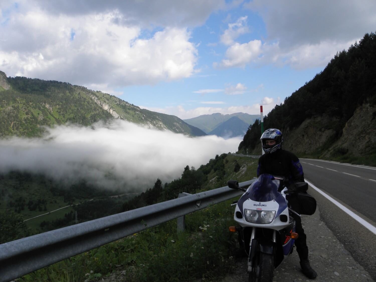
 We wanted to get to Suse in Italy and there spend the night, as it was getting a bit late. Unfortunately we did not find any campsite there, so we moved on, driving through yet another mountain pass located at two thousand meters. It rained on the way and it got cold, but the views compensated those inconveniences. Mountains hidden behind clouds and dimmed sun trying to break through the clouds – we had to stop for a quick photo session.
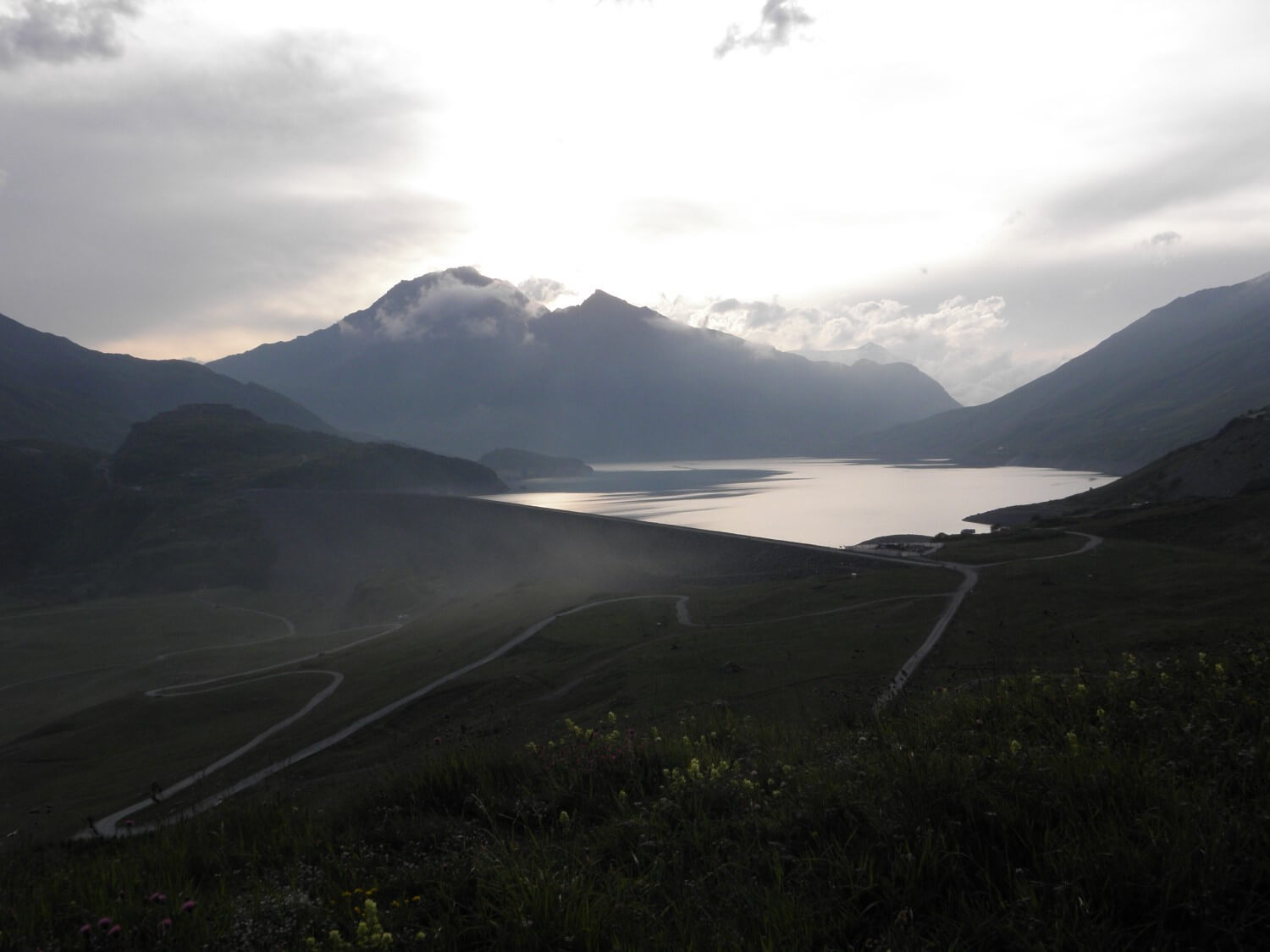
We descended the mountain pass and we entered France again. Fortunately we found the campsite in the first village on our way (Lanslebourg) with stunning views of snow-capped mountains. We wanted to finish the day with a cup of hot tea, but we quickly had to hide in the tent, as it started to rain.
DAY 18. FROM FRANCE THROUGH ITALY TO SWITZERLAND
Lanslebourg Mont Cenis, France –> Camping near Reckingen-Gluringen, Switzerland (217 miles)
 Hairpin bends continuation, but today the drive was much more pleasant, because the roads were of better quality and the visibility was much better. Right after we packed our tent (unfortunately wet), we set off. First on our way were the Col de L’Izeran, and then the Little St. Bernard Pass, which took us to Italy. The drive was very good, and the views splendid.
Of course, again, we had problems with finding picnic tables. Throughout our journey some adversity was pestering us – when we were looking for a picnic table there weren’t any, and once we ate something on a parking lot, soon after that we passed 10 picnic sites! Heart failing.
 The next mountain pass – the Great St. Bernard Pass took us to Switzerland and there we had some problems, as we had to buy the map and get some Swiss francs. With the latter there was no problem, but we spend some time looking for a map. It the end we bought the one covering whole Alps, unfortunately folded one, but better than none.
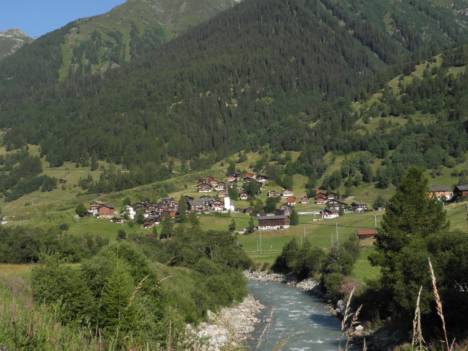
Switzerland surprised us with the quantity of vineyards – located on the mountain slopes, high, steep, but everything neatly in perfectly straight rows. Swiss villages in the mountain valleys are very charming. Wooden houses, granaries beautifully presented against lush green mountain sides – in one of such charming villages we spend the night, enjoying an excellent dinner at a local hotel’s restaurant.
DAY 19. MOUNTAIN PASSES DAY
Camping near Reckingen-Gluringen, Switzerland –> Camping Cima Piazzi near Valdisotto, Italy (241 miles)
We started with the Furka Pass and finished with Passo de Bernino. In the morning, when we were driving through the first mountain pass it was very cold and cloudy. I thought it will stay like that for the rest of the day.
 Fortunately the sky cleared up, and when we were driving in the valleys it was quite hot. Today again we had no luck with picnic table, but instead we ate our breakfast on the river bank.
We decided to get off the bike for a while and we stopped at a tourist attraction which was a ravine, worn by the rocks set in motion by the flowing water. It was along the road no 17 near Moritz.
We also had the opportunity to admire the Morteratsch glacier (Switzerland) – at the exit on the road no 29.
To fully enjoy the taste of Italy we had Italian pizza for a dinner, it was very good:)
DAY 20. WET AND CLOUDY
Camping Cima Piazzi near Valdisotto, Italy –> Camping Michelnhof near Sankt Johann in Tirol, Austria (267 miles)
All day long we tried to hide from the clouds. In the morning the rain woke us up and I thought we will get stuck at the campsite, but thankfully it cleared up and before 9 we managed to pack up.
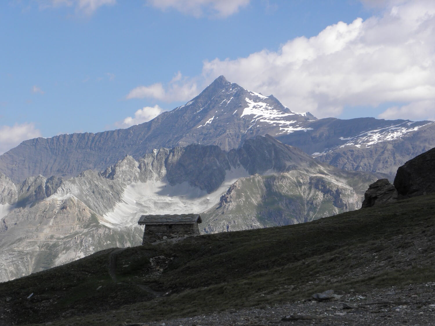
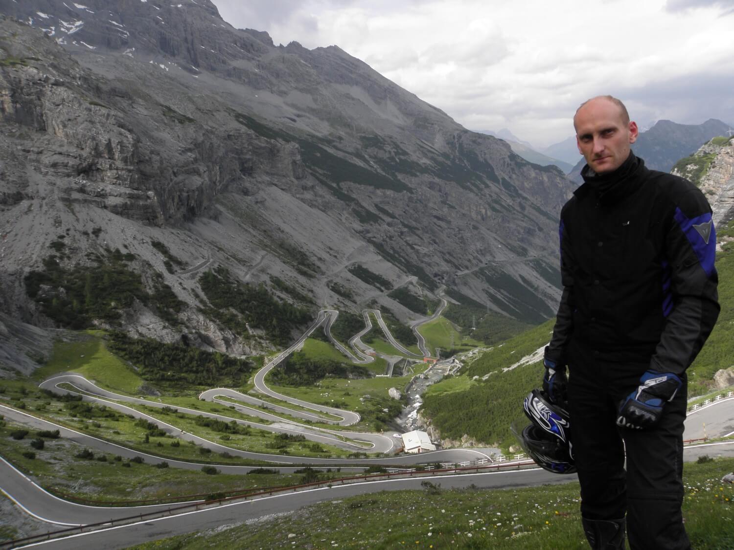 In the morning we challenged Passo dello Stelvio, driving countless hairpin bends, passing an organized group of scooters and stumbled across a sport cars photo session (including the Bugatti Veyron). We drove down the pass in clouds so unfortunately we did not have the view over the entire pass, but the drive itself was an amazing experience.
With our luck as usual, we could not find any picnic table, so we ate breakfast at the bus stop. Maybe it was for the good, because it started to rain and the bus stop was our shelter.
Driving towards the next mountain pass – Pass Trafoi, it started to rain heavily and visibility dropped below 20 meters. We did not stop for long at the top. Going down the other side of the mountain, the fog and clouds were gradually disappearing and with every minute the sky was clearing up, we were driving towards the sun.
Then we crossed the passes: Pass Rambo-Timmelsjoch, Gerlos Pass which were paid, as most passes in Austria, where we’ve just drove in.
 Luckily the heavy rains spared us. Even at the end of the day when we were following a massive dark cloud and in front of us it was pouring down, we were staying in the sunshine. It was only slightly colder. And so we arrived at the campsite, which we probably will remember for a long time – we haven’t seen such exclusive campsite yet; it was a pleasure to relax in such a clean and warm bathroom, and then sit down in a restaurant discussing a plan for journey back home.
NOTE – The roads in Austria are very well marked, but unfortunately we could not avoid all the diversions and road works.
DAY 21. THE WAY BACK
Camping Michelnhof near Sankt Johann in Tirol, Austria –> Grünstadt, Germany (344 miles)
What a night it was! A terrible storm with lightning, thunders and a downpour. I had difficulties in falling asleep. In the morning we experienced and attack of snails on our tent, they did races, who can climb faster to the top before being kicked out of the game (by one us of course:). I thought it will stop raining before morning and we will wake up in the sunshine, but unfortunately we were greeted by clouds and rain. We did not feel like packing up in such weather but it was pointless to sit and wait. Fortunately, we got the chance when it stopped raining for a while and we packed up quickly. We said goodbye to Austria in the rain and in the rain we entered Germany. There we quickly got on to the motorway, which we followed all day, towards the sun, which we finally have the opportunity to enjoy and I warmed myself up a bit after a cold morning.
Our bad luck for diversions didn’t left for a moment and even when we pulled into the petrol station we had to follow the diversion to get back on the road:/ The drive was going quite well, until we got to Ludwigshafen – where because of a closed road we had to follow poorly marked diversions and we were driving round in circles probably for an hour if not more, just to get on the right road. Once we found it, as we decided earlier we drove into the first village on our way in a search for accommodation.
DAY 22. BACK HOME
Grünstadt, Germany –> Leicester, England (596 miles)
We woke up early in the morning, had a small breakfast and set off. The drive was going very well and we moved ahead fast. So we decided that we will get back home tonight – which meant a whole day of driving the motorways and a ferry crossing. Everything went surprisingly good and after 9pm we were already back home. Full of memories, exhausted, we fall asleep like children in comfortable beds. And so our adventure came to an end.